


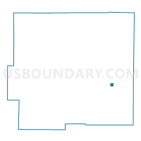
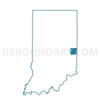
WAYNE 10, Wayne County, Indiana
About
Outline

Summary
| Unique Area Identifier | 581203 |
| Name | WAYNE 10 |
| County | Wayne County |
| State | Indiana |
| Area (square miles) | 0.19 |
| Land Area (square miles) | 0.19 |
| Water Area (square miles) | 0.00 |
| % of Land Area | 100.00 |
| % of Water Area | 0.00 |
| Latitude of the Internal Point | 39.82635920 |
| Longtitude of the Internal Point | -84.88339480 |
Maps

Graphs
Select a template below for downloading or customizing gragh for WAYNE 10, Wayne County, Indiana


Neighbors
Neighoring Voting District (by Name) Neighboring Voting District on the Map
- WAYNE 05, Wayne County, IN
- WAYNE 07, Wayne County, IN
- WAYNE 08, Wayne County, IN
- WAYNE 11, Wayne County, IN
- WAYNE 15, Wayne County, IN
- WAYNE 26, Wayne County, IN